Study Authority:
The study was authorized by Section 203 of the Water Resources and Development Act (WRDA) of 1986 (PL 99-662) as modified by Section 1014 of Water Resources and Reform Development Act (WRRDA) 2014. Also, by Section 1126 of the Water Infrastructure Improvements of the Nation Act (Public Law 114-322) which is also known as WRDA of 2016, and section 1152 of WRDA 2018. Section 203, as amended via the above referenced provisions, allows non-Federal interests, such as GLPC, to undertake feasibility studies of proposed navigation projects and submit them to the (ASA-CW).
In accordance with Section 203, as amended, GLPC prepared “Port Fourchon Belle Pass Channel Deepening Project Section 203 Feasibility Study,” dated January 2019 and revised January 2020, which it submitted to the ASA(CW) for its review assessment which was then transmitted to Congress.
The Project is conditionally authorized by WRDA 2020 Section 403. “PORT FOURCHON BELLE PASS CHANNEL, LOUISIANA. —The project for navigation, Port Fourchon Belle Pass Channel, Louisiana, as described in the review assessment of the Secretary, titled ‘‘Review Assessment of Port Fourchon Belle Pass Channel Deepening Project Section 203 Feasibility Study (January 2019, revised January 2020)’’ and dated April 2020, at a total cost of $95,483,000.” The project cannot proceed to construction until the outstanding issues from the Review Assessment have been resolved and the ASA(CW) transmits the Final Assessment to Congress.
Historical Authorizations
The existing Port Fourchon navigation project was authorized by Section 101(a)(16), WRDA 1996 for a navigation channel in Belle Pass and Bayou Lafourche from Gulf of Mexico (mile 0.0) to mile 3.4 at a depth of -24 feet Mean Lower Low Water (MLLW) over a bottom width of 300 feet, and an entrance channel extending approximately 1.3 miles from the gulf shore to the -27 foot MLLW contour with a depth of -26 feet MLLW over a bottom width of 300 feet, as generally described in the Port Fourchon, Louisiana Feasibility Report and Environmental Impact Statement, dated August 1994, and approved by the Chief of Engineers on April 7, 1995. The Corps completed construction and has maintained the authorized navigation project.
Proposed Action:
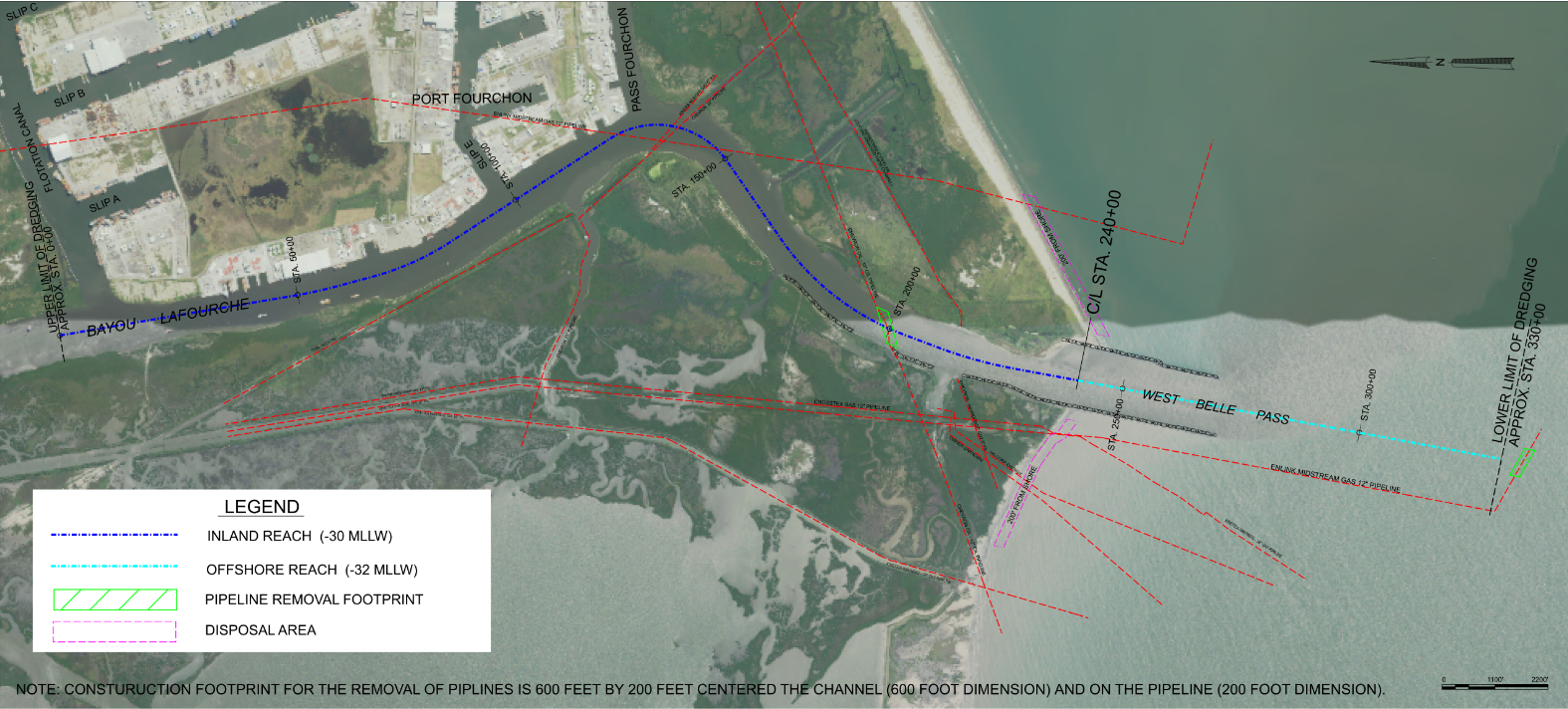
The proposed action is a dredge operation, with initial deepening and maintenance, which was considered through a 50-year period of analysis, to provide enhanced navigation to shipping industry in the Federal channel of Bayou Lafourche, Louisiana. Deepening of the Federal navigation channel beyond the dimensions of the project that was authorized in WRDA 1996 would be achieved by the same dredging operation that is currently used for maintenance. The existing maintenance project was authorized for a navigation channel 300 ft wide with an elevation of -24 ft MLLW on the inland reach from Mile 3.4 to Mile 0.0 and to an elevation of -26 ft MLLW for the offshore reach from Mile 0.0 to Mile -1.3. The proposed action would dredge the Federal navigation channel to an elevation of -30 ft MLLW for the inland reach plus 3 ft of advanced maintenance and to -32 ft MLLW for the offshore reach plus 4 ft of advanced maintenance (Figure 1). The proposed action follows the alignment of the existing maintenance project and extends to the newly authorized dredge limits following the natural contour of the Gulf of Mexico. Dredging would be accomplished with a hydraulic cutter-head dredge and material excavated would be transported to two (2) sites in a slurry via pipeline. The two dredge material disposal sites are the same as what is currently utilized for the routine maintenance dredge events and located on the exterior of the existing jetties near the intersection with the existing shoreline. Discharge location would be 200 ft offshore and would extend 300 – 3000 ft from the jetties in the shallow open water and be allowed to flow (as shown in Figure 1 above). Construction access for dredge, attendant plant, and discharge line is in open water. No upland areas would be utilized for construction or maintenance of the project.
Purpose and Need:
The study’s purpose is to investigate increasing the controlling depth of the Bayou Lafourche Waterway Federal navigation channel at Port Fourchon, Louisiana, to an engineering, economic and environmentally feasible depth and extend the main access channel to the natural contour of the Gulf of Mexico at the optimum depth. The objective of the proposed project is to increase the channel depth of Bayou Lafourche inshore and offshore to accommodate deep draft vessels used for industrial purposes. Accommodating deep draft vessels is important to the public interest as well as being important to advance the USACE role in deep draft navigation in order to provide safe, reliable, and efficient waterways for the movement of commerce, national security needs, and recreation (ER 1105-2-100).

Map of the proposed Federal action location in Bayou Lafourche in Port Fourchon, Louisiana. The proposed Federal action for dredging is denoted by the blue lines (dark blue line denotes inland reach, which is being dredged to -30 ft MMLW, and the light blue line denotes the offshore reach which is being dredged to -32 ft MLLW) and the proposed dredge material disposal areas are denoted by the pink lines. Pipeline removal footprints are denoted by two lime green boxes.