History

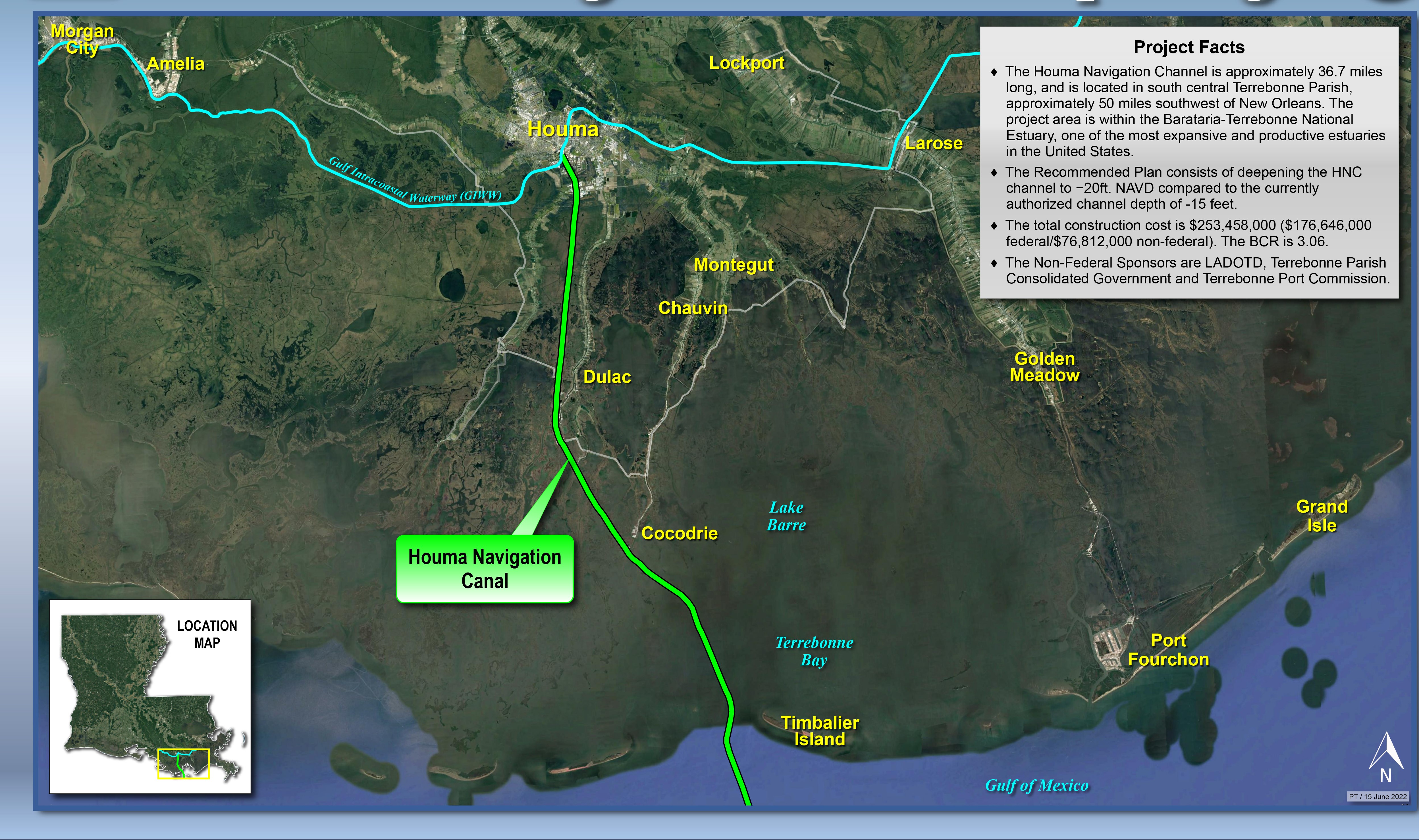
The Houma Navigation Canal (HNC) provides a navigation channel between Houma, Louisiana, and the Gulf of Mexico south of the eastern end of Isles Dernieres.  The Rivers and Harbors Act of 1962 provided for the maintenance of a 15-foot-deep by 150-foot-wide channel from Houma, Louisiana, through Terrebonne Bay and an 18-foot-deep by 300-foot-wide bar channel to the minus 18-foot contour in the Gulf of Mexico, after its construction by local interests.  Construction of the 150-foot channel was completed in 1962, and the bar channel was enlarged to a 300-foot width in 1974.  Maintenance of discontinuous reaches of the channel has been accomplished on an as-needed basis since the Corps of Engineers assumed project maintenance in 1962.  Historically, material dredged from the HNC during maintenance was deposited confined in upland confined disposal areas, along the bankline, and in open water.  Project maintenance is divided into three reaches: 1) Inland reach Mile 36 to Mile 12, 2) Terrebonne Bay reach Mile 12 to Mile 0, and 3) bar channel/Cat Island Pass, Mile 0 to Mile -5.   

Project Description

The Houma Navigation Canal is a Federally maintained waterway that connects the Gulf Intracoastal Waterway in Houma with the Gulf of Mexico. The Recommended Plan, which is the national economic development plan, consists of deepening the HNC channel to −20 (North American Vertical Datum of 1988) feet compared to the currently authorized channel depth of -15 feet. The plan also provides for the construction of rock foreshore protection and retention dikes for channel bank erosion control, reduction of sedimentation in the channel, and for retention of dredged material. The disposal plan provides for beneficial use of dredged material by placing material in locations and quantities with earthen containment structures to restore wetland habitats.


Project Focus, Risks, and Importance

The current channel depth causes marine interests to use less efficient methods to service the offshore oil and gas facilities located in the Gulf of Mexico.


 Large vessels will not be able to pass through the channel efficiently. This will result in increased waterborne transportation costs.


Houma, Louisiana, is a large center for shipyard work for the offshore marine sector for the construction of new vessels and for regular repairs of licensed vessels.  It also serves as a hub for service and supply for the offshore oil industry.  With exploration activities occurring in deeper waters of the Gulf of Mexico, large vessels with more capacity are needed.  As such, a deeper waterway is needed to reduce current waterborne transportation costs to allow the use of fully loaded larger vessels, as opposed to more trips with smaller vessels or light loaded large vessels.  This would also allow for the efficient passage of large oil and gas sector barges, new vessels built or repaired at the Houma shipyards.
 

    Location

    The Houma Navigation Channel is located in south-central Terrebonne Parish, approximately 50 miles southwest of New Orleans. The project area is within the Barataria-Terrebonne National Estuary, one of the most expansive and productive estuaries in the United States