Lafitte Area Flood and Coastal Storm Risk Management Study, Louisiana

About

Collapse All Expand All
 Study Authority

United States House of Representatives 105th Congress, Resolution Docket 2554, dated May 6, 1998.

 Scope

The general scope of the study includes a comprehensive investigation of flood risk management problems and opportunities in the study area, which will be conducted in compliance with Smart Planning Principles.  The study will seek to mitigate damages from all sources of flooding for various levels of risk reduction.  Mitigating strategies, which may include structural measures, such as levees, floodwalls, and pump stations, as well as nonstructural measures, will be developed in close coordination with the non-Federal sponsor the Coastal Protection and Restoration Authority Board of Louisiana, stakeholders, local communities, and others through informal and formal venues.  Intended outcome is a Chief’s Report that can be transmitted to Congress.  The Letter of Intent supporting this study was signed on 25 January 2022 by the non-Federal sponsor.  The Feasibility Cost Sharing agreement was signed on 17 August 2023.

 Risk

Hurricanes, tropical storm events, storm surge, tidal flooding, and heavy rainfall pose a significant risk to over 3,500 people residing in the study area.

 Location

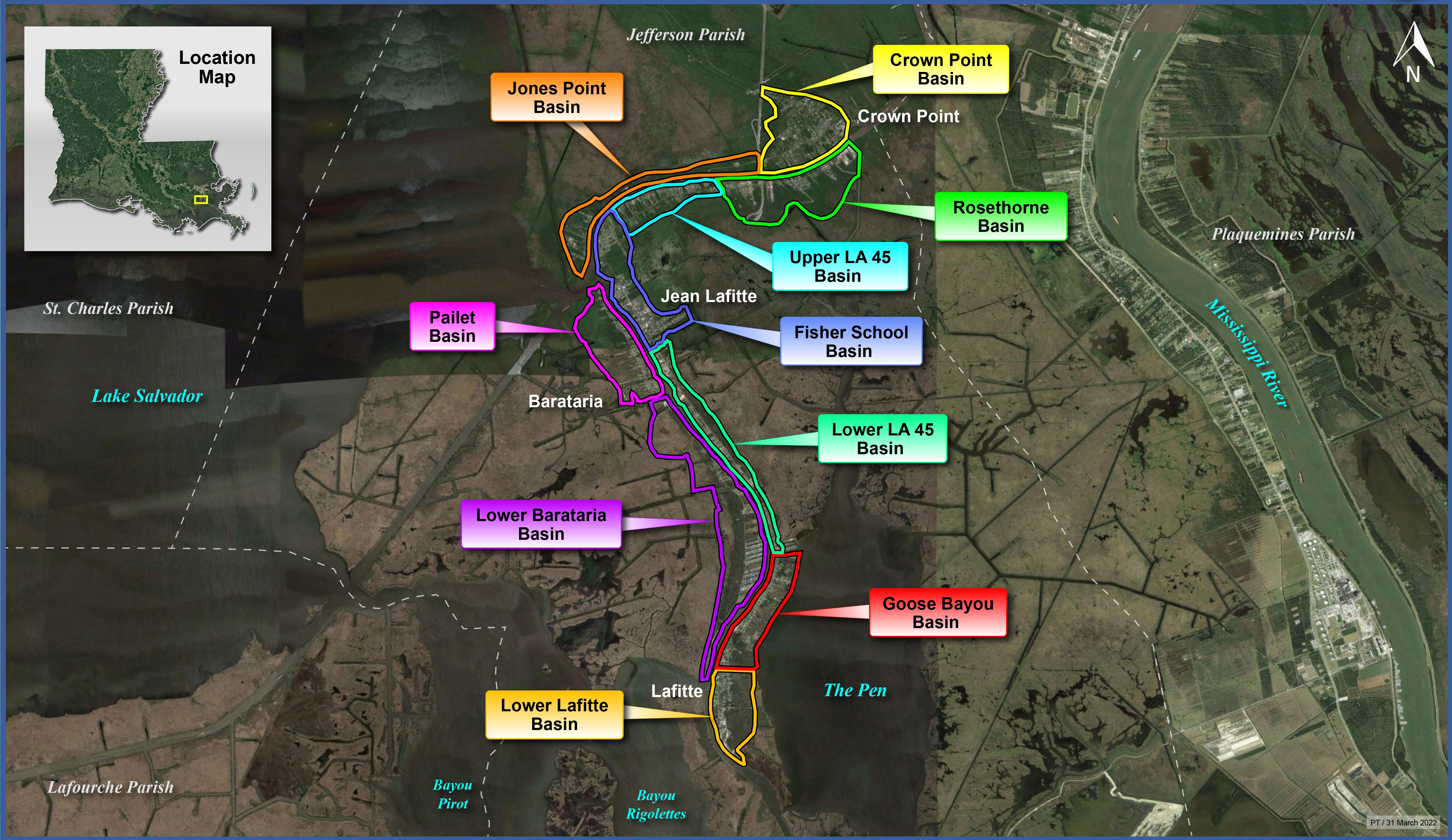
The study area includes the unincorporated community of Laffite and adjacent coastal communities such as Crown Point, Jean Lafitte, and Barataria, located in lower Jefferson Parish in Southeast Louisiana, about ten miles south-southwest of New Orleans and just east of Lake Salvador.

 Issues

The study area is subject to flooding from hurricane and tropical storm surge, rainfall flooding, and riverine flooding. Disaster declarations were issued for Hurricanes Zeta and Ida in 2021 as well as Hurricane Laura, Tropical Storms Cristobal, and Marco in 2020. Hurricane Ida made landfall as a Category 4 hurricane and resulted in widespread devastation to this area, from which recovery remains ongoing.

 Importance

Vulnerable to sea level rise, high tides, and storm surge, the study area continues to see devasting flooding impacts due to rainfall and tropical storm events, which threaten the culturally rich communities as well as the area’s largest industries including agriculture, forestry, fishing, and hunting. Additionally, the study area is known for producing seafood and oil and gas and is surrounded by vast expanses of deteriorating wetlands and the neighboring Jean Lafitte National Historical Park and Preserve.  

 Description

The purpose of this study is to investigate flood and coastal storm risk management throughout this low-lying coastal area. The study will seek to mitigate damages from all sources of flooding for various levels of risk reduction. Mitigating strategies, which may include structural measures, such as levees, floodwalls, and pump stations, as well as nonstructural measures, will be developed in close coordination with the non-Federal sponsor the Coastal Protection and Restoration Authority Board of Louisiana, stakeholders, local communities, and others through informal and formal venues.  

Study Area

Located in lower Jefferson Parish in Southeast Louisiana, about ten miles south-southwest of New Orleans.

Includes unincorporated community of Lafitte, Crown Point, Jean Lafitte, and Barataria.

Unique Considerations for study area:

  • Vulnerable to sea level rise, high tides, and storm surge. Continues to experience catastrophic flooding from various storm events.
  • Culturally rich community with agricultural lands, forestry, and recreation.
  • Significant contributor to commercial seafood industry and oil & gas industry.
  • Adjacent to Jean Lafitte national Historical Park & Preserve.
  • Adjacent to EPA-regulated sensitive habitat.
  • Surrounded by vast expanses of deteriorating wetlands.