Official Project Name 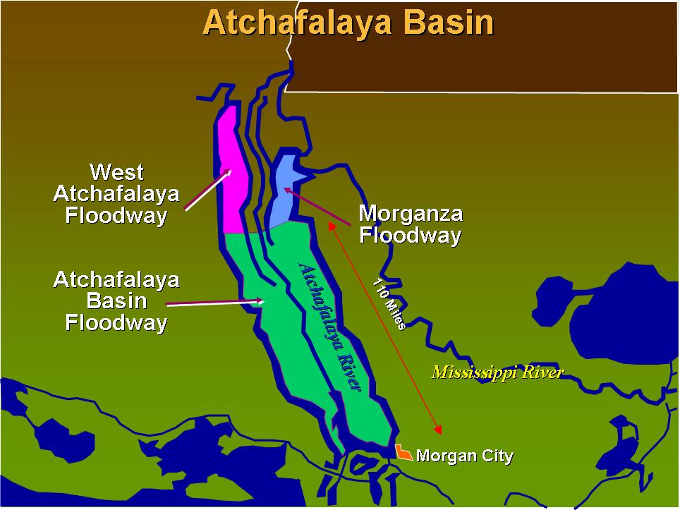
Lower Atchafalaya Basin Floodway System
Location
The entire Atchafalaya Basin is located in south-central Louisiana and extends from the confluence of the Mississippi, Red and Atchafalaya rivers near Simmesport, Louisiana to the Gulf of Mexico south of Morgan City. The 833,000-acre Lower Atchafalaya Basin Floodway is bounded on the north by U.S. 190, on the east and west by the Atchafalaya Basin protection levees, and extends south to the Gulf of Mexico.
Purpose
The Lower Atchafalaya Basin Floodway System project has two mutually supporting goals: to preserve the habitat of nation’s largest and oldest river-basin swamp and to ensure that the Lower Atchafalaya Basin can pass a floodwater of 1.5 million cubic feet per second as required by the Mississippi River and Tributaries Project (MR&T).
Status
No Information at this time.
Benefit to the Community & Project Features
Benefit to the Community
The Atchafalaya River is the largest of all distributaries of the Mississippi River. Improvements in the upper Atchafalaya Basin include a system of levees, locks and other structures that manage water flow.
The Lower Atchafalaya Basin Floodway System project includes six identifiable requirements—water management, recreation, public access, environmental protection, flood control, and water circulation/canal closure.
Features
• Water Management Units (WMUs)
The project includes five water management units that will improve water quality, enhance fish and wildlife, and control sediment flow. Congress has authorized construction of two units to serve as pilot projects.
--The Buffalo Cove WMU which is located in the southwest portion of the basin, and
--The Henderson Lake WMU, which is located just below Krotz Springs extending south from U.S. 190 to below Interstate 10.
The remaining three: Flat Lake, Beau Bayou and Cocodrie Swamp Management Units have passed the preliminary planning and assessment phase but have not yet entered the construction phase.
• Recreation
The Water Resources Development Act of 1986 authorized the Corps to develop recreation opportunities within the lower Atchafalaya Basin Floodway System. Facilities include features such as boat landings, campgrounds and an interactive visitor center. The federal government provides half of the funding for study, design, and construction with the local sponsor providing the rest. When complete, the local sponsors are fully responsible for operation and maintenance of the facilities.
New boat landings have been constructed at Simmesport and Myette Point. Additional boat landings are planned for Bayou Sorrel, Krotz Springs, Butte LaRose, and Bayou Pigeon. These sites will include launch ramps, parking, access roads, rest rooms, drinking water, lighting, piers and other features.
Two additional features, a lake end parkway on Lake Palourde and an Atchafalaya Basin Floodway System Interpretive Center are currently inactive pending the completion of the DSEIS and revised authority.
• Real Estate Acquisition
The Corps is in the process of identifying and acquiring as much as 388,000 acres in easements and 70,000 acres in fee land in the basin to ensure public access and preservation of the basin and its unique habitat for future generations. Real estate acquisition is ongoing.
• Habitat Monitoring
Together with the US Geological Service, the US Fish & Wildlife Service, and the Louisiana State University, the Corps of Engineers monitors water quality, samples fish populations, and tracks changes in gage readings, synoptic discharge and bottom sediment and accretion. These efforts help to ensure the health of the Lower Atchafalaya Floodway System.
Authority
Flood Control Act of May 15, 1928, Public Law 391; Supplemental Appropriations Act of 1985, Public Law 99-88; Water Resources Development Act of 1986, Public Law 99-662; Water Resources Development Act of 1988, Public Law 100-202; Water Resources Development Act of 2000, Public Law 106-541; and Water Resources Development Act of 2007, Public Law 110-114.
Scope
No Information at this time.