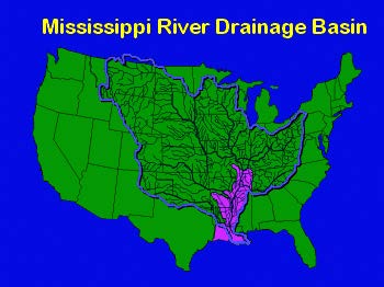
The Mississippi River has the third largest drainage basin in the world, exceeded in size only by the watersheds of the Amazon and Congo Rivers. It drains 41 percent of the 48 contiguous states of the United States. The basin covers more than 1,245,000 square miles, includes all or parts of 31 states and two Canadian provinces, and roughly resembles a funnel which has its spout at the Gulf of Mexico. Waters from as far east as New York and as far west as Montana contribute to flows in the lower river.
 The Mississippi River Drainage Basin, The Mississippi River Drainage Basin,
with Mississippi River &Tributaries Project area (in pink). |
The lower alluvial valley of the Mississippi River is a relatively flat plain of about 35,000 square miles bordering on the river which would be overflowed during time of high water if it were not for man-made protective works.This valley begins just below Cape Girardeau, Missouri, is roughly 600 miles in length, varies in width from 25 to 125 miles, and includes parts of seven states -- Missouri, Illinois, Tennessee, Kentucky, Arkansas, Mississippi, and Louisiana.
Floods of 1849 and 1850, which caused widespread damage in the Mississippi River Valley, revealed the national interest in controlling the mighty river.
|
By the year 1879, the need for improvement of the Mississippi River had become widely recognized. The necessity for coordination of engineering operations through a centralized organization had finally been accepted.
Accordingly, in that year, the Congress established the Mississippi River Commission and assigned it the duties. . . " to take into consideration and mature such a plan or plans and estimates as will correct, permanently locate, and deepen the channel and protect the banks of the Mississippi River, improve and give safety and ease to navigation thereof, prevent destructive floods, promote and facilitate commerce, trade, and the postal service."
The Commission was to consist of three officers of the Corps of Engineers, one of whom would be President; one member from the U.S. Coast and Geodetic Survey; and three civilians, two of whom would be civil engineers. All appointments would be nominated by the President of the United States, subject to confirmation by the Senate.
In 1882, three years after establishment of the Commission, one of the most disastrous floods ever known devastated the entire delta area. The losses were appalling. During that flood there were hundreds of crevasses, and the outlook for a permanent solution to flooding in the Mississippi Valley was disheartening.
Major floods again occurred in 1912, 1913, and 1927. The flood of 1927 was the most disastrous in the history of the Lower Mississippi Valley. An area of about 26,000 square miles was inundated. Levees were breached, and cities, towns, and farms were laid waste. Crops were destroyed, and industries and transportation paralyzed.
Property damage amounted to about $1.5 billion at today's prices. Over 200 lives were lost and over 600,000 people displaced. Out of it grew the Flood Control Act of 1928, which committed the federal government to a definite program of flood control. This legislation authorized the Mississippi River and Tributaries (MR&T) Project, the nation's first comprehensive flood control and navigation act.